Estimated reading time 14 minutes, 9 seconds.
During the latter 20th century, scores of ships transiting Canadian waters dumped their toxic bilge water – a mixture of oil, solvents, and other chemicals deadly to marine lifeforms – into the domestic maritime environment. Crew members typically waited until night to get rid of the pollutants, sparing their employer, the ship’s owner, the cost of having the liquids properly disposed of in port. With the longest coastline of any country – 202,000 kilometres along the Pacific, Arctic and Atlantic Oceans, plus the Great Lakes – and 6.55 million square kilometres of continental shelf and territorial waters, jettisoning bilge water undetected in Canadian waters was easy and commonplace.
The principal victims of the illegal ship pollution were seabirds; countless perished and oil-coated avian corpses washed ashore by the thousands in Atlantic Canada, alarming coastal residents and scientists. Lamentably, the area southeast of Newfoundland became one of the world’s most contaminated marine zones. To stop the harmful practice, the federal government initiated aerial surveillance operations in 1968, starting with patrols above the Great Lakes and St. Lawrence Seaway.
NASP Evolution
In 1991, the Canadian Coast Guard (CCG) decided to expand aerial monitoring of ships in Atlantic and Pacific waters, and created the National Aerial Surveillance Program (NASP) to that end. In December 2003, responsibility for NASP was transferred to Transport Canada (TC). The program’s main goals are to prevent pollution from ships; protect the marine environment; strengthen Canada’s maritime security; work to make Canada a world leader in aerial marine reconnaissance; and, to support environmentally-friendly economic development.
NASP objectives include the enforcement of maritime regulations, pollution deterrence, emergency response support, and ice reconnaissance, among others.
Supporting Federal Organizations
“Transport Canada works closely with Environment Canada and the Canadian Coast Guard in all aspects of the National Aerial Surveillance Program,” Louis Armstrong, NASP program manager, told Canadian Skies in an interview.
“We have marine aerial reconnaissance teams, or MARTs, that gather timely, accurate and useful information during NASP flights. The data enables various government departments and agencies to fulfil their mandates as they apply to the oceans that border our nation, as well as the Great Lakes and the St. Lawrence.”
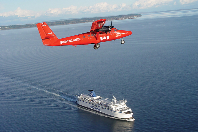
In addition to Environment Canada and the CCG, NASP works with Fisheries and Oceans, National Defence, and Justice Canada. “When maritime pollution occurs, MART personnel confirm the vessel’s location, digitally record the spill, communicate with the ship’s crew, and report to the Coast Guard Regional Operations Centre,” said Armstrong. “Information collected by NASP aircraft and personnel is also distributed to the federal organizations charged with determining if a response or investigation is needed.”
NASP Resources
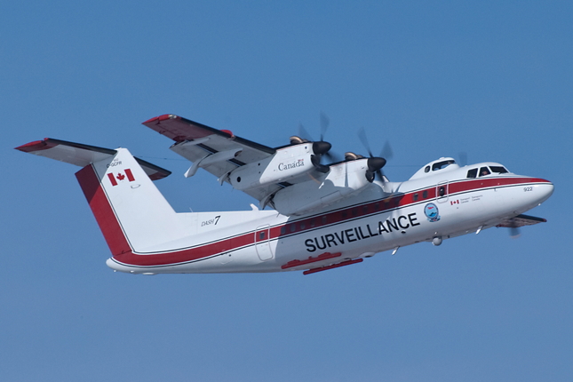
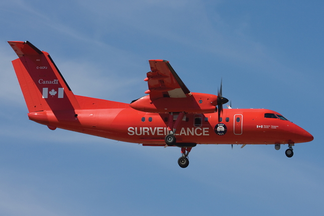
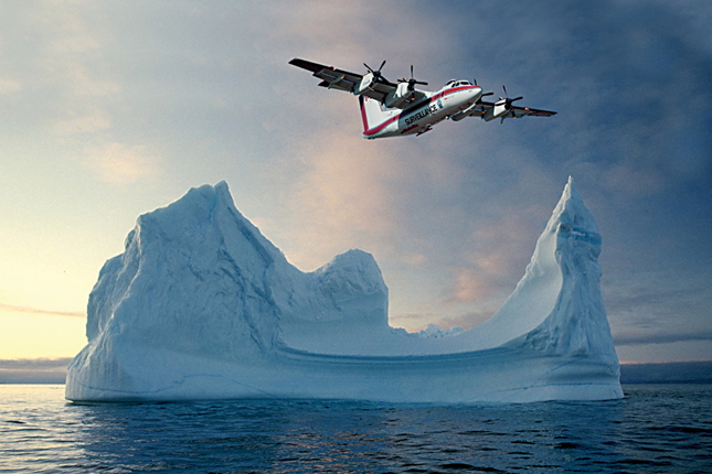
The main NASP resources are its personnel (43 staff) and a specially-equipped fleet of two de Havilland Dash 8s and a Dash 7. One Dash 8 is based in Atlantic Canada in Moncton, N.B., and the other on the West Coast in Vancouver. The Dash 7’s home base is in Ottawa from November to late June. Otherwise, it is stationed in Iqaluit, Nunavut, on the southeastern coast of Baffin Island. From this base, it performs ice reconnaissance flights and pollution patrols across the Arctic.
Ice reconnaissance missions are typically carried out to determine detailed routing for Coast Guard icebreakers and merchant ships. During these flights, there are three people in the Dash 7’s cabin, including one in the upper observer position, looking at and charting ice formations. During pollution patrols, each aircraft is manned by two pilots, a surveillance system operator, and an observer (the operator and observer rotate hourly). NASP pilots receive aircraftspecific training with FlightPath International, an Alliston, Ont., company.
Swedish Surveillance System
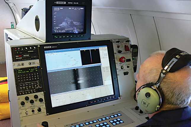
“The three maritime surveillance systems [MSS] acquired from the Swedish Space Corporation for the NASP planes detect, classify and track all targets of interest, including ship pollution,” Armstrong explained. “The surveillance capabilities of the equipment are excellent and provide our MARTs with the technological tools required to track and identify polluters 24/7, and in all weather conditions.”
Transport Canada conducts about 25 to 30 per cent of its NASP pollution patrols at night. Armstrong said that regardless of the hour, surveillance flights occur not only to monitor marine traffic, but also to send a message to ships’ crews and owners: dumping toxins into Canadian waters without detection is improbable and will result in legal action (e.g., ship seizure, fines). Remarkably, very few contaminated seabirds have washed ashore in recent years, since NASP surveillance began. International shipping and cruise line companies, in particular, know that their vessels are being monitored from above as they move through Canadian waters.
Electronic Gear
Transport Canada’s three NASP aircraft are equipped with:
• A side-looking airborne radar (SLAR) that detects irregularities on the ocean’s surface, even in reduced visibility. This hi-tech system has greatly extended aerial surveillance from the human eye-range of a couple of nautical miles, to as far as 45 nautical miles electronically.
• An infrared/ultraviolet line scanner, which helps staff analyze oil slicks and provides high-resolution imagery of marine pollution. The equipment also detects water temperature differences on the surface and maps spills of oil and other substances.
• An electro-optical infrared camera system that aids NASP crews in the identification of ships and evidence collection, even in low visibility.
• An automatic identification system (AIS) that displays vessel identity and voyage information to MART members and allows them to digitally map the vessels. AIS tracks ships by electronically exchanging data with nearby vessels and base stations. The International Maritime Organization’s International Convention for the Safety of Life at Sea requires AIS to be installed on all ships of 300 or more tons that operate in international waters, and all passenger ships regardless of size.
• A geo-coded digital camera system that enables NASP personnel to capture still images and video with GPSannotated data such as date, time, longitude and latitude. Photographs and videos are used as evidence during prosecution of polluters.
• A satellite-based communications and data transmission system used to stream video in near-real-time to ground stations during flights.
Equipment manufacturer Swedish Space Corporation explains on its website that data from all surveillance systems is processed and presented in one integrated operator view. GPS data is integrated into recordings and all files are digitally stored. As well, the equipment will replay and analyze a recorded mission on a separate ground work station.
ISTOP
Armstrong said NASP is an innovative and efficient operation. “NASP crews have worked hard to make Canada a global leader in marine aerial pollution surveillance and reconnaissance. We maximize each patrol hour by multi-tasking with other government departments, and by taking advantage of not only the advanced remote sensing equipment on the aircraft, but also satellite surveillance through the ISTOP.”
ISTOP, the Integrated Satellite Tracking of Pollution Program, is an Environment Canada marine pollution early warning system that uses Canada’s RADARSAT- 1 and -2 remote-sensing platforms in space. In less than an hour and a half, ISTOP analysts receive and review data from the satellites about any irregularity at sea and can initiate an aerial investigation via a NASP team, if the information so warrants.
“Evidence gathered [with NASP equipment] contributes to the enforcement of domestic and international laws,” Armstrong explained. “Our MARTs have helped successfully prosecute several maritime polluters.”
A Warmer Future
Scientists from Canada and other countries have repeatedly warned that the Arctic is heating up faster than the rest of the planet due to anthropogenic (human-caused) greenhouse gases, and the release of methane previously trapped in the ice and permafrost. Consequently, Arctic waterways have been ice-free this decade for longer periods, a new reality that has affected NASP operations and will continue to do so in the foreseeable future.
By mid-September 2012, Arctic ice covered 3.41 million square kilometres, nearly one-fifth less from the previous low of 4.17 million sq. km. in 2007. “Over the past several decades, the impacts of a warming global climate have been acutely felt throughout the Arctic,” Dr. David Barber, Director of the Centre for Earth Observation Science at the University of Manitoba in Winnipeg, told Canadian Skies in an email. “The melting of sea ice, glacial ice, permafrost and the attendant physical and biological consequences is unprecedented. One of the most visible effects of Canada’s warming Arctic has been the opening of shipping routes that were previously closed due to ice.”
A few months ago, federal environment minister Peter Kent told Postmedia News that climate change “is a concern and it is not going to be reversed any time soon…we have to adapt.” To quote the report, adaptation means that “Ottawa is bolstering its ice monitoring and Arctic meteorological services.”
Senior Canadian Ice Service forecaster Trudy Wohlleben added: “For the Canadian Ice Service, it means we’re busier than ever, because more and more ships want to go to the Arctic. Boats are popping up everywhere.” In the past, only CCG, supply vessels and Inuit craft plied Arctic waters. Now, sailboats, yachts, and cruise and cargo vessels traverse the region, increasing the risk of pollution from ships.
Because of the changes in Canada’s North, more surveillance aircraft may be required to monitor vessels and act as a deterrent to polluters. For now, the three NASP planes are adequate, according to Armstrong, who said they are “babied” in terms of maintenance and will be flown for years. “Wear and tear on the surveillance equipment and advances in electronics mean that the systems will be replaced before the aircraft,” he observed.
Finally, Transport Canada’s declared NASP commitment is to “continue to protect the marine environment, enhance marine safety and security, and support economic development for the benefit of coastal communities and all Canadians.”
Climate change is affecting our oceans, yet the Harper government has reduced funding for Transport Canada, Environment Canada, and the Coast Guard as part of its deficitreduction strategy. It remains to be seen if Transport Canada will be able to continue to fulfil its NASP commitment in the future. Whatever the challenges, Armstrong and his National Aerial Surveillance Program colleagues will continue to work diligently to safeguard Canada’s maritime environment.
Blair Watson has written aviation articles and news reports for publishers and media companies in Canada, the U.S., and Britain since 2005. His work has been syndicated to MSNBC, Yahoo! News and FOX News and read by millions of people. His 23-year aviation career includes commercial flying, air traffic control training, airport operations and project management, technical writing, and airline instructional design.