Estimated reading time 2 minutes, 18 seconds.
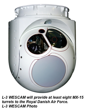
L-3 WESCAM announced that it has received an acquisition and sustainment contract from the Danish Defence Acquisition and Logistics Organization (DALO) to provide a minimum of eight MX-15 electro-optical and infrared (EO/IR) imaging systems for the Royal Danish Air Force’s (RDAF) EH101 aircraft. System deliveries are expected to be complete by 2014.
Installation of the turrets will be done by DALO, while certification and configuration management will be provided by AgustaWestland. The newly equipped EH101s will then be deployed to the RDAF’s 722 Squadron in support of RDAF Tactical Troop Transport (TTT) operations, training exercises within Denmark and possible future use in mission theatres globally. Maintenance of the MX-15 systems will be performed by DALO at its existing maintenance facility in Frederikshavn, Denmark.
“This order pairs the most modern TTT helicopter with an advanced EO/IR sensor suite that provides crucial day/night imaging capabilities for a broad range of missions,” said Paul Jennison, vice president of government sales and business development for L-3 WESCAM. “We are proud to be selected as a contributor to this important fleet enhancement program and are looking forward to a long and successful partnership with the RDAF, DALO and AgustaWestland.”
The MX-15 system has been engineered as a single line replacement unit solution, which reduces installation weight by 25 percent and increases much-needed cabin space for transporting equipment, evacuees and personnel.
The MX-15’s all-digital, high-definition EO and IR cameras will provide increased visual range and wider fields-of-view than traditional standard-definition cameras. In addition, the systems will be configured with a zoom TV, high-magnification spotter TV, two laser sensors and MX-GEO Gen. 3 – a package that includes GEO-Scan, GEO-Tracking and Adaptive-GEO technologies. Together, this software suite helps deliver maximum geographic location accuracy and significantly reduces operator workload in demanding and stressful operations.