Estimated reading time 16 minutes, 37 seconds.
“Springbank Clearance, Hailstop 5 requesting immediate departure for the 280-degree radial, 110 miles, and we’ll need a block from 18,000 to 21,000.”
My work day was about to get really interesting!
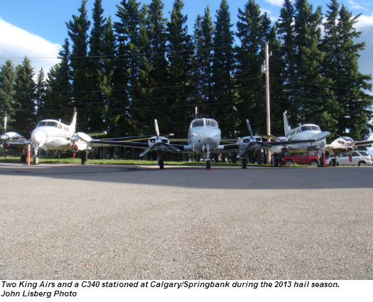
My co-pilot and I had been on airport standby since 1200 hours. During the 2013 summer storm season, we were one of three hail suppression flight crews based at the Calgary/Springbank Airport (YBW). There were two more crews based at the airport in Red Deer, Alta. We had all been standing by, in operational readiness, for another day of trying to tame the notorious thunderstorms that rip through Southwestern Alberta during the summer.
The storms create hundreds of millions of dollars’ worth of damage from June to mid-September, in an area aptly named “Hail Alley.” This roughly 1,200 square kilometre swath of the Canadian Prairies can become a maelstrom of hail when conditions are just right. During the peak of the wheat, oats, canola and barley crop growth, due to photosynthesis, there is a large release of added moisture into the air, which gets further warmed by the sun. If that moist air flows up against the slopes of the Rocky Mountains and collides with the dry air that is being pushed east from the B.C. interior—voila! Instability!
Most of the time, that instability produces only rain. But, as recorded over the last 100 years, that instability can deliver much worse. If all conditions are met, about 40 to 60 hailstorms rear their ugly heads each year. Spectacular displays of raw, devastating energy and destruction lie in their wakes. In 1991, an early September hailstorm caused nearly $350 million in property damage. Again in 2010 and 2012, even more destructive hailstorms caused more than a half billion dollars’ worth of damage. They all occurred in Calgary and some of its surrounding suburbs, with each storm lasting less than 45 minutes! The hail shredded large trees as though they were matchsticks. Houses and apartment buildings had glass windows shattered; siding and roofs were pulverized. The majority of motor vehicles, caught in the swath, were complete insurance write-offs.
Over the years, the damage caused by hailstorms in the vicinity of Hail Alley has cost Alberta insurance companies billions of dollars in compensation. In 1996, over 110 of those companies banded together and formed the Alberta Severe Weather Management Society. Their intent was to try to find a solution that would contain or at least temper the damage created by the hailstorms, and thereby decrease the amount of claims.
The Society hired Dr. Terry Kraus as its project director. He then contracted Weather Modification Inc., based out of Fargo, N.D., to provide crews and aircraft for hail suppression. Weather Modification Inc. has done hail suppression and rain/snow enhancement operations for nearly 30 years, in numerous countries throughout the world.
Storm seeding
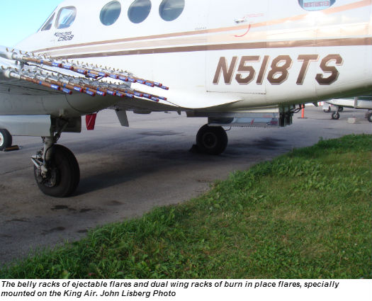
The Alberta project involved three King Air 90s, specially fitted with over-wing and belly racks. In addition, two Cessna 340s were specially fitted with over-wing racks and outer-wing burner cans. The over-wing racks carry flare-like pyrotechnical devices. The three underbelly racks hold 103 bomb-like pyrotechnical devices per rack. The devices are ignited, singularly or in groups, by an arming/release unit that is controlled from the cockpit. Once ignited and released from the aircraft, they burn and introduce a solution of silver iodide particulates into the cells of a building thunderstorm.
The King Airs are used for “top seeding” from 12,000 feet AGL up to about 25,000 feet AGL. The aircraft is flown into the building thunderstorm cell and literally bombs it. The “bombs” are ignited as they are released, usually one at a time, from the belly racks. They burn for approximately three minutes and drop through about 3,000 to 4,000 feet in that time span. While burning, they discharge the silver iodide particulates into the growing thunderstorm cell. These particulates provide more surfaces for the microscopic water droplets inside the cell to adhere to. In this way, many smaller hailstones are created, as opposed to the larger ones which would form if the particulates were not as numerous.
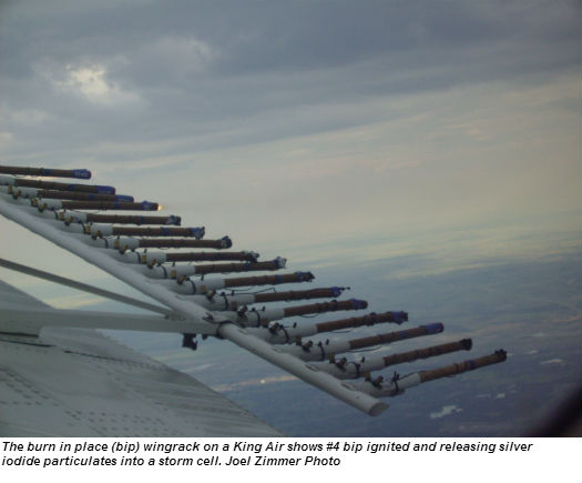
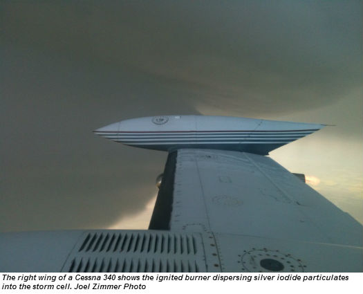
The Cessna 340s perform the “base seeding,” flying at altitudes ranging from near the surface to approximately 10,000 feet, depending on the base of the cloud. They are flown clear of the cloud, about 300 to 500 metres out from the base of the storm cell. It’s in this region that an inflow of air feeds the updrafts that are building the storm cell. The C340s will ignite their burners and/or their wing rack flares as they skirt the outer edges of the storm cell. This further introduces more silver iodide particulates into the air that is flowing into the building cell. The King Airs can also be used in this fashion, if required, to spell off the C340s. Each King Air has a dual over/under wing rack containing a total of nearly 100 flares. These can be ignited singularly or in groups to further inject more “particulate smoke” into the growing thunderstorm cell.
All the hail suppression flight crews get a daily weather briefing and forecast at 1200 hours sharp. The brief/forecast is provided via conference call by a team of three meteorologists based at the Olds-Didsbury airport (CEA3), who utilize high tech meteorology software to prepare the briefing. This is also where the company’s weather radar site is located, because it is central to the Hail Alley area and gives full coverage north of Red Deer, east to the Rocky Mountains, south of Lethbridge, and about 60 miles east of Calgary’s city limits.
The day’s forecast was laced with ominous words. “Wind shear/speed shear, latent instability, cloud cover increasing, gusty winds, wind index 61 mph, insolation, loaded gun…” As well, the met team’s operational information forecast was rated a +4, with +5 being the highest rating, which translates to “mega” thunderstorms.
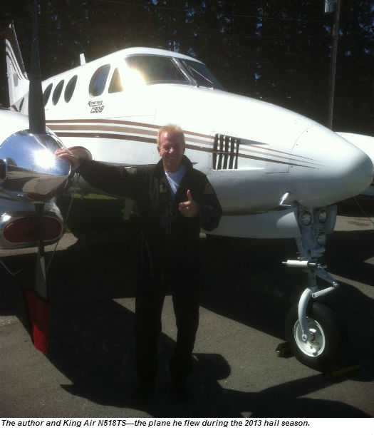
“Hooo boy, I think we’re going to make up for this bit of relaxation we’ve been enjoying,” I said, to no one in particular. A chorus of, “You got that right!” echoed back in response. We were definitely going to be earning our paycheques based on that forecast. After the weather brief I walked out to my plane, N18TS, which was a King Air 90 with the Raisbeck Engineering modification and four-bladed props.
My walk-around had been done before the noon weather brief. I just wanted to spend a few minutes alone with the plane. It gave me an opportunity to mentally prepare myself for the upcoming events which looked certain to unfold soon.
Riding the air
In mid-afternoon, the call came through. We were launched! We hurried out to the airplane, did a fast walk-around, then climbed on board, cinching seat belts and shoulder harnesses tight. Closer to the storm we would cinch them up even tighter, to the point of hardly being able to breathe or move. You don’t want loose objects, including yourself, hurtling around in the airplane when Mother Nature is doing her best to dislodge you from the skies!
We generally request a buffer zone of 1,000 feet above and generally 2,000 feet below the aircraft. This is to allow the “bombs” to burn up and disperse into the atmosphere. It wouldn’t be the best thing to “bomb” an unsuspecting aircraft that might be flying with only 1,000 feet or so of separation between us!
We were airborne and climbing as fast as we could to get to altitude and the developing storm cells. We could already see the area blackening and associated lightning flashes ahead. I was flying and talking with radar. My co-pilot was talking with ATC to keep them up to date on our intentions and the track and strength of the developing hailstorm. That way, it gives them a better idea of where to vector aircraft. You might say that we are their eyes in the sky.
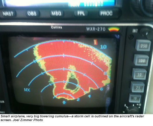
The meteorologists’ forecast of a +4 was bang on. We hadn’t reached any major cells yet, but were already getting tossed around the sky by the updrafts and downdrafts. Radar had given me the headings and runs that they wanted us to try.
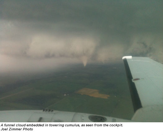
As the airborne crew, we assessed the building storm and tried to plan for the variables. I bugged my escape exit, cinched up my harnesses, cranked up the cockpit lighting and hunkered down for what was sure to be a roller coaster ride. PHWOOOSH!!! It got dark real fast! Rain was streaming off the windscreen. No more sunlight or broken cloud; we were now immersed in the cell. We were hit with negative Gs as we entered the cloud. I can still feel the top of my Lightspeed headset bouncing off the cabin roof.
WHAAAAM!!!! As we penetrated the thunderstorm further in, updrafts and downdrafts continuously pushed and pulled at us. We had gained two to three times our body weight and I was struggling to maintain a stable flight path. Don’t panic, ride the air! Let the plane do its thing. Don’t force any dramatic inputs into the flight controls. Planes fly best when the wings are attached!
My co-pilot began to fire the “bombs.” He started burning a couple of flares as we entered the cloud, but now we knew we were immersed in the area where the hail begins to form. This was our best chance to hit the storm cell as hard as we could. We bounced around, losing a couple of thousand feet, gaining one or two thousand, and just trying to stay upright and relatively stable.
PHWOOOSH!!! Just as fast as we had entered, we were spit out the other side into more stable air. The plane’s radar gave us an idea of our position within the cell, but it can be a bit of a shock (and relief) to be spit out on the other side. We continued on into more cells that were building ahead of us.
As we flew, either myself or my co-pilot was updating the meteorologists at our radar site. Radar incorporates our information with their software programs and makes interpretations on the fly (pun intended there). At the same time, we were also communicating with ATC and our other crews that were seeding in the vicinity. Radar might have us flying in one quadrant at a specific altitude, and also have another King Air flying opposite us at a couple of thousand feet higher or lower. As well, the base seeders, who were flying much lower, give their input regarding the cell’s characteristics.
During really bad hailstorms, we had all five aircraft launched and hammering away at various quadrants of the storms in an effort to suppress their destructive energy. Under these circumstances it’s imperative that all aircraft are fully aware of each other’s whereabouts. ATC is also working hard at giving other aircraft a wide berth from our intended routes and altitudes.
We were in and out of the cells for the next two-plus hours. After a while, you lose the feeling in your legs and butt. Your shoulders ache and your arms feel like lead from trying to maintain the control column and the power inputs. We definitely didn’t fly on autopilot. It was all hand-flying. I felt as though we were intruding on the ancient battlegrounds of the Norse gods, Odin and Thor. The thunderstorms’ fury and ferocity made me feel puny and very mortal. The King Air just hummed along.
The storm continued its onslaught, hammering away at us and at the ground so far below. Time slowed to a crawl as we pitted ourselves against the turbulent air and lightning. We forged in and out of the storm, round and round in a racetrack pattern, trying our best to overcome the elements.
“Hailstop 5, RTB.” Radar gave us the welcome instruction to return to base. The storm had begun to die or was moving out of the area. I called ATC and advised that we were coming in, and requested vectors for the approach. I gave them a final update on the storm, its strength and possible track. We entered calmer air. I loosened my shoulder harness and seat belt and wriggled around in the seat, trying to get some circulation back. The pins and needles were almost a welcome feeling.
My co-pilot was working on completing the flight log and a tally of the ejectables and flares expended. He looked up and then outside, where I was looking at the incredible, yet savage, beauty of the retreating and dying storm. I don’t think there are really any words that can truly describe what we see during these flights.
I gave a smile and a small shake of my head. Then, “Descent checklist, and after that you have control for the approach and landing.” We were on our way back to prepare for the next time.
John Lisberg is an ATPL licensed pilot in Canada, the U.S., and several other countries, with over 4,500 hours total time. He has done contract work in Canada, the U.S., Alaska, the Caribbean, Maldives, Africa and the South Asia region. He is presently flying as captain on a Beech 1900 based in Vancouver, B.C.