Estimated reading time 10 minutes, 54 seconds.
Halifax, Nova Scotia-based CarteNav Solutions recently shared the behind-the-scenes details of an unexpected search-and-rescue (SAR) mission that took place back in the fall of 2021.
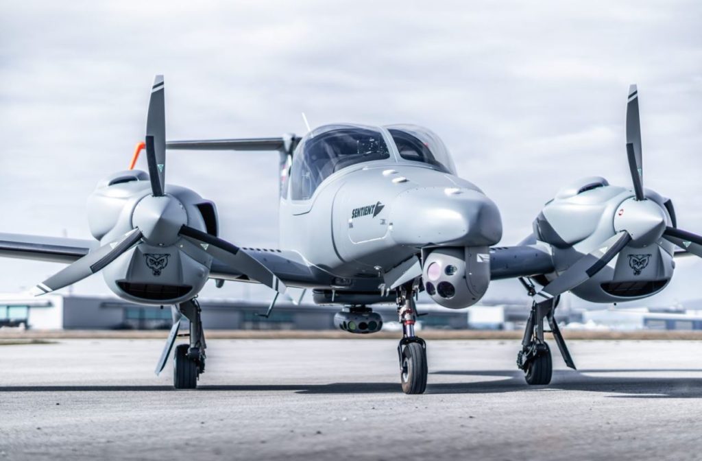
The Special Mission Aircraft Division of Austria-based Diamond Aircraft undertook a series of demonstrations of a new surveillance and SAR capability, based on its DA42 MPP, out of Ostend, Belgium. The aircraft was equipped with CarteNav’s AIMS-ISR mission management system, a Trakka EO/IR turreted sensor, and Sentient Vision System’s ViDAR VMS-5 surveillance pod.
On day two of the demo, an emergency call came in regarding “a small boat transporting 24 migrants” in the North Sea “off the coast of Zeebrugge.” Four of the migrants were reported to be “in distress.”
“Having performed a demonstration with the Diamond Aircraft DA42 MPP (multi purpose platform) for the Coast Guard the day before, October 27th’s demonstration was set to be a routine one. Suddenly an emergency phone call from the Belgian Maritime Rescue and Coordination Center thrust the aircraft into action,” CarteNav said in a statement.
Sentient said that multi-day demonstration was the first time that its “VMS-5 (ViDAR Maritime Surveillance) Day/Night optical radar pod was utilized in its operational configuration on a fixed-wing aircraft.” ViDAR stands for Visual Detection and Ranging. Sentient said it’s “the world’s first optical radar system.”
Diving into the rescue operation, the fast-thinking crew had the aircraft readied and airborne in under 15 minutes; locating the lost migrants floating in an unknown location in the North Sea was the new mission.
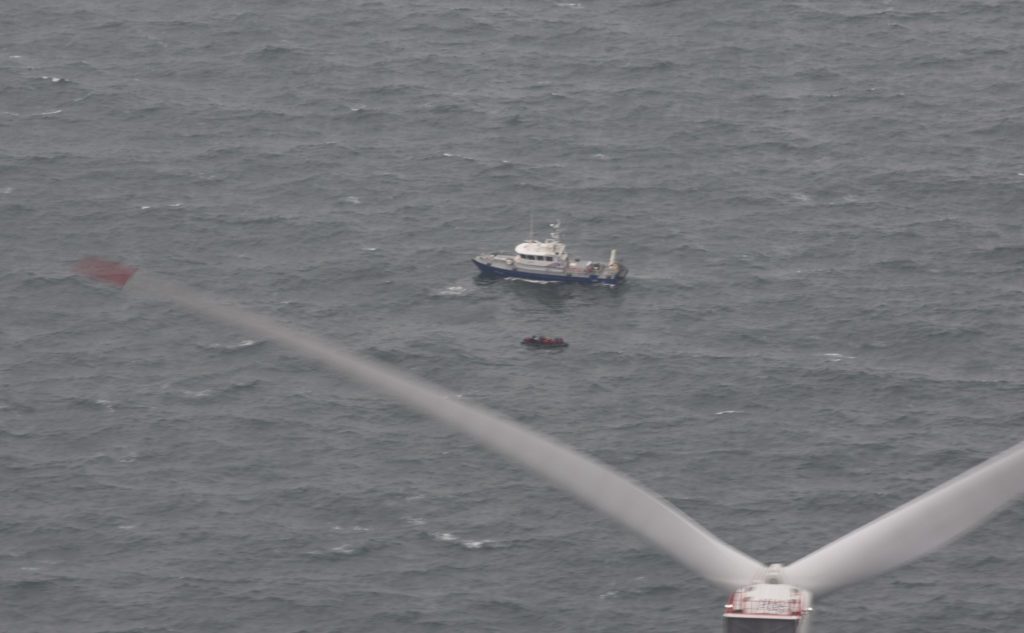
“Adrift in the North Sea for 48 hours, after running out of fuel, the only positional information that was reported from the call for help was that they were near a massive offshore wind farm,” said CarteNav’s director of marketing, Trevor Bradley.
Inclement weather forced the special missions aircraft to fly at 1,000 feet at 120 knots. Just 20 minutes after takeoff, the “tiny dingy” containing all 24 people was located, “thanks to the collaboration between Sentient Vision’s ViDAR and Trakka Systems’ EO/IR camera, all under CarteNav’s AIMS-ISR mission management system software.”
“We integrated a wide range of sensors on this aircraft, for a wide range of applications from area survey to search-and-rescue and ISR (intelligence, surveillance, and reconnaissance),” said Diamond Aircraft’s sales manager of special mission aircraft, Mario Spiegel.
“Search challenges included rough seas, fast wind farms, and the inflatable craft,” added Bradley.
Employing “tidal flow modeling,” the crew was able to target an initial search area.
According to Sentient, ViDAR can “cover a designated search area up to 100 times faster than an aircraft without ViDAR.”
“[It] can survey wide areas of maritime environments very quickly with a really simple integration,” explained Sentient’s senior integration engineer, Gavin Edwards. “And the purpose of this demonstration was to provide an insight to our customers and potential customers.”
Sentient’s ViDAR uses artificial intelligence and computer vision in an on-board processor to search each frame in the imagery feed from an EO/IR sensor to detect moving targets as small as a human head in the water.
CarteNav’s AIMS-ISR smart filters are able to remove “irrelevant mission data,” such as windmills. And the “multi-cue lock tracking automatically keeps the cameras, radars, and other sensors focused on the targets of interest,” the company said.
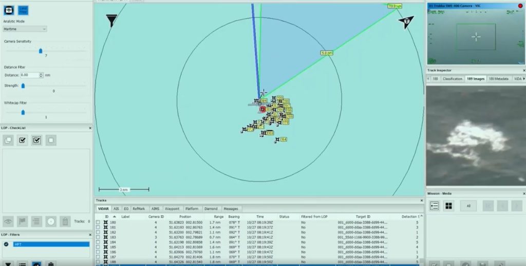
“We know where we’re pointing, and we know where the surface of the water is with all that information; we have a completely passive detection capability,” said Edwards.
Halifax-based CarteNav develops situational awareness software for the maritime, land, and air environments. The company’s vice president of product, Scott Richardson, described partnering with companies like Sentient as revolutionary and helpful in reducing operator workload.
“Using technology intelligently without overwhelming the operator is the key thing here,” agreed Edwards. “When you’re trying to detect things that [could] potentially be two pixels by two pixels, there’s no room there for false positives.
“New technology sensors are getting smaller and more lightweight. So, you get better capability at [a more practical] weight and size, which obviously benefits a relatively small aircraft,” he continued. “We can literally do the same job as a big aircraft for a fraction of the cost. [And] we’re [trimming] down [what would normally be] a 90-minute search pattern to four-and-a-half minutes, and we can do that every single time. We weren’t there 10 years ago. But, we’re very much there today.”
The crew shared the location with the Belgian Coast Guard and continued to monitor the situation. A Belgian Coast Guard NH90 helicopter and the Belgian Navy provided assistance, including a medic who “boarded the shipwrecked boat close to an offshore wind farm area.”
The Governor of Belgium’s West Flanders province, Carl Decaluwé, told The Associated Press that of the 24 migrants, five were airlifted to safety, and the rest were transported to land by boat.