Estimated reading time 14 minutes, 43 seconds.
Test your instrument flight rules (IFR) proficiency and sharpen your piloting skills with this exclusive Skies feature!
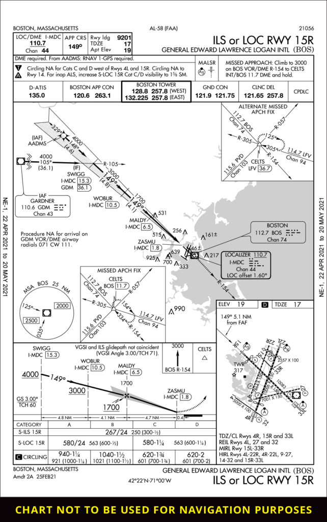
Examine the approach plate below and take your best shot at the accompanying quiz.
Boston, Massachusetts (BOS) / ILS or LOC RWY 15R
Did you see that… ?
You get a call from a friend asking if you want a box of lobster fresh from their fishing boat.
Being that it’s fresh Maine lobster, you say, “Absolutely!” As a professional aviator, you take a look at the weather in KBOS, and it is IFR conditions all along the eastern seaboard with southeast winds. That’s no problem for you, because you are a seasoned instrument pilot. You perform your preflight action and hop in your plane to start making your way to KBOS.
- GPS in lieu of DME? Maybe…
Like many GA airplanes, your old DME receiver has been deactivated and labeled “inop” (or better yet, completely replaced) since your avionics upgrade and installation of a GPS. The approach requires DME, as noted in the upper left corner: “DME required.”
Your next thought may be, “I can use the GPS in lieu of DME.” Right!? Well, let’s take a closer look at the type of GPS that will allow you to do this…
The GPS capabilities will depend on the Technical Standard Order (TSO) certification. These capabilities are outlined in AC 90-108 (pp. 4-5), which says that a TSO-C129/-C145/-C146 unit may be used in lieu of DME for en route and terminal operations. The WAAS GPS receiver may be used in lieu of DME, too (TSO-C145/-C146). In the present case, the GPS would be used to identify the aircraft’s distance and to satisfy the DME requirement. This is one of the four approved ways to use the GPS in lieu of DME for Part 91 operations.
Which TSO-C129/-C145/-C146 is your GPS? This is where you would have to look at the airplane’s operator manual, specifically in the flight manual supplement. (This manual is typically towards the back of the operator’s manual in the supplement section.) The TSO certification would most likely be found in the general or limitation section of the flight manual supplement (see a sample flight manual supplement for a GNS 430W here).
Do you know what kind of TSO certification your GPS is?
2. Weather is below approach minimums. Can I start the approach?
As you come into the KBOS area, you listen to the ATIS. The ceilings are 200’ vertical visibility and 1/4 mile visibility due to fog.
Next, you take a look at the weather minimums; you see the minimum weather for the ILS 15 straight in is 300’ ceilings and 1/2 mile visibility. Can you start the approach? Well, yes, you could, because fresh lobsters are at stake.
Under FAR Part 91 operations, you could legally start the approach, even if the weather is “zero-zero.” But whether you can actually land is determined at the Decision Altitude or Minimum Descent Altitude.
Here is when FAR section 91.175 comes into play. Again, for Part 91 operations, you could attempt the approach; however, if you want to continue below the Decision Altitude/Decision Height (DA/DH), you must take a few things into account: 1) The aircraft is in a position from which descent to a landing on the intended runway can be made using normal maneuvers; 2) The required flight visibility is not less than the required visibility listed for the approach; and 3) The runway environment (which is carefully defined within FAR 91.175(c) with 10 specific items).
So, here are some options: 1) You could attempt the approach, but you may not be able to descend below the DA/DH; 2) Depending on the winds, you may want to look at another runway to see if there is another approach with better weather; or 3) You could consider diverting to another airport with more favorable winds and weather.
If you were to choose another runway, the type of approach lighting system will often signal the type of approach minimums. For example, some airports have favored runways when the weather is lower because the lighting systems allow for a lower approach minima. Looking at the airport diagram on the bottom left of this chart, it appears the higher intensity lighting systems are for Runway 4R and 33L. A quick flip through the approach plates for KBOS 4R and 33L verifies that the approach minimums are lower than for KBOS 15R. (Note: This plate is used as a platform for discussion. These options may serve better at a smaller GA airport. KBOS may not accommodate an adverse flow approach.)
3. Where is my Visual Descent Point?
When on the ILS approach, the missed approach point is the DA/DH. But say the glide slope is NOTAM’d as inoperative. Therefore, you would have to use the localizer minimums. In this case, the missed approach point is 0.4 miles from the runway at ZASMU, or 1.8 DME from the I-MDC localizer. Another way to find a missed approach point for a localizer approach is time, but there is no time listed on this approach.
You note that there is no Visual Descent Point (VDP) symbology. If you plan descent to the runway from the missed approach point, then you will be 0.4 nm from the runway, and at localizer minimums of 580’ MSL. If you come to the minimum descent altitude with just under 0.4 nm from the threshold, this would likely end up in a very steep approach to the runway. This is far from the “normal maneuvers” to make a normal descent required by FAR 91.175. The localizer or non-precision approach could set you up to fail with the missed approach point being so close to the runway. By planning a VDP, your success of meeting 91.175 for “normal maneuvers” to descend to the intended runway increases.
Here are some ways to calculate your own VDP:
1) Pull out the whiz wheel (E6B): For a three-degree glide slope you will need about 1.8 nm to descend out of 580’ MSL to touchdown zone elevation of 17’; or
2) Divide your height above touchdown by 300. The result will give you nautical miles from the runway to begin a three-degree glide slope. (580-17 = 563’ to lose, or the height above touchdown); 563/300 = 1.8 nm.)
3) Determine altitude to lose (in thousands) and multiply by three, then add 10 percent. For example: 580’ to lose will require you to be 1.7 nm from the runway for a three-degree descent. (0.5*3 = 1.5 + 0.2 = 1.7 nm.)
A good thought process to keep in mind: “If I do not see the runway at a minimum descent altitude of 580’ MSL by 2 nm from the runway, I will go missed, because I probably will not be able to satisfy the ‘normal maneuvers’ requirement of 91.175 to descend to the intended runway.”
4. What does CIRCLING mean on this approach plate?
Let’s say as you are starting the approach, the tower notifies you that they want you to plan on circling to Runway 22R. Presuming we have the weather for circling, you look down at the approach plate and see the negative “C.” (Note: Again, this is for a discussion, and probably would not happen at KBOS, unless it is super quiet or maybe at night.)
Starting in 2012, the standard circling minimums have changed as noted by the negative “C.” (See Aeronautical Chart Users’ Guide.) The change to the TERPS criteria provided improved obstacle protection depending on the altitude above the airport and approach airspeed.
The below graph shows that with increased aircraft speeds, the radius around the airport for the circling approach will expand and thus provide expanded obstacle or TERPS protection for the circling approach. The graph also shows that at higher elevation airports, more circling radius is required because of your higher true airspeed.
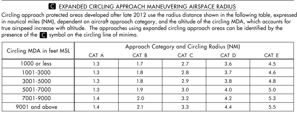
Taking a closer look, let’s say you are in a Category B aircraft, maybe a King Air; for a circling approach you will need 1 1/4 statute miles of visibility. The expanded circling approach chart shows that you will be allowed 1.7 nm of a circling radius for this approach. Looking back at FAR 91.175 in order to descend below minimum descent altitude, you must have the runway environment, no less than the required flight visibility, and use “normal maneuvers” to descend to the intended runway. These circling minimums and minimum required flight visibility seem pretty close to minimum visibility to see the runway environment. While you are allowed to circle farther from the airport, you may not be able to maintain the runway environment per 91.175.
If your approach speed is faster (categories C and D, for example), the circling radius may be greater than the minimum weather flight visibility required; keep in mind your ability to maintain the runway environment to meet 91.175 to descend below minimum descent altitude.
5. With synthetic vision, I can go lower than the published approach minimums?
To enhance situational awareness, you mounted your mobile device with synthetic vision to your windshield or yoke mount.
Synthetic vision is available in popular aviation flight tool apps. While it is a great situational awareness tool, it is not approved as a means of navigation for an instrument approach; nor does it allow you to descend below MDA/DA/DH of 91.175; nor will it reduce your minimums. It is a situational awareness tool only to help identify where the runway may be located — for example, as you come down the approach path with a stiff cross wind.
During your risk assessment, would you consider using synthetic vision when going into an airport where the weather minimums are lower than your personal minimums?
Next time, we’ll have more thought-provoking discussions of instrument procedures; some may spark conversations around the pilot lounge with colleagues — or better yet, have you pulling out the reference sources to see for yourself.